


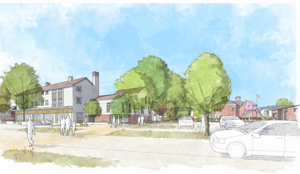

Welcome to this digital case study of the proposed regeneration of the Stocking Farm Neighbourhood Centre, created on behalf of Leicester City Council for the students of Babington Academy.
Leicester City Council has identified Stocking Farm Neighbourhood Centre as a priority for investment. It is important to us that any investment will ensure that the Neighbourhood Centre meets the needs of local residents for many years.
Leicester City Council have previously hosted three stages of public consultation with local residents, initially seeking their views on the current Stocking Farm Neighbourhood Centre, and later asking their opinions on the proposals for the regeneration of the area.
This website will guide you through what we learned from the public consultations and our initial proposals for the Stocking Farm Neighbourhood Centre. You will then have the opportunity to complete a short quiz at the end.
Read audio transcriptinfo Look out for red highlighted text like this - it will indicate interactive features on the map.
If you have any questions or need help, please see the
Frequently Asked Questions (FAQs). If these do not answer your question, please raise your hand and ask your teacher.| Stocking Farm Neighbourhood Centre |
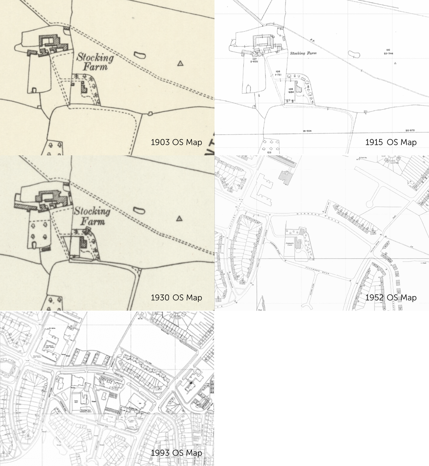
In previous consultations, many members of the community have submitted vivid memories of how Stocking Farm used to be.
info Watch the above historical maps to see Stocking Farm through the ages. Then click on the map markers to see fascinating historical images of the Stocking Farm Farmhouse, the former Stocking Farm Youth Centre, and St. Luke's Church!
Until the mid-twentieth century, Stocking Farm lay on the city's outskirts, surrounded by open fields. Today's Farmhouse was built at the turn of the 19th century, slightly to the south of the original farmyard and house located where Woodstock Primary Academy stands today.
A keen sense of community has always been apparent. Did you know
that the local community built St. Luke's Church over several years
as part of its move from Humberstone Road, with construction
starting in April 1961?
However, some later developments around the site have been less
unified, resulting in underused areas that do not contribute to
their full potential. The following pages explore our thoughts on
how this could be addressed.
| Stocking Farm Neighbourhood Centre | |
| Historic photographs |
In the second stage of public engagement (October / November 2021), the community told us what was most important to them regarding the regeneration of Stocking Farm Neighbourhood Centre.
info We have listened to the feedback from the local community and have used it to inform our proposals. Click on the map markers to find out more about our plans!
They told us that:
| Stocking Farm Neighbourhood Centre | |
| Proposed improvements | |
| New traffic calmed street | |
| Improved greenway/footpath | |
| Existing footpath | |
| New homes | |
| Retained buildings | |
| Car park | |
| Community Shop, Community Hall & Outdoor Community Space |
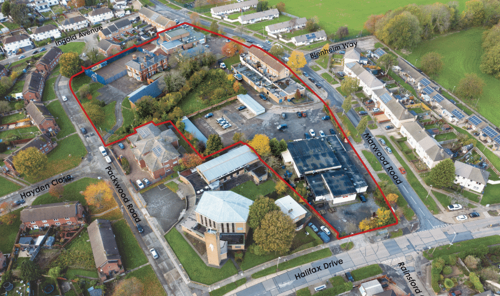
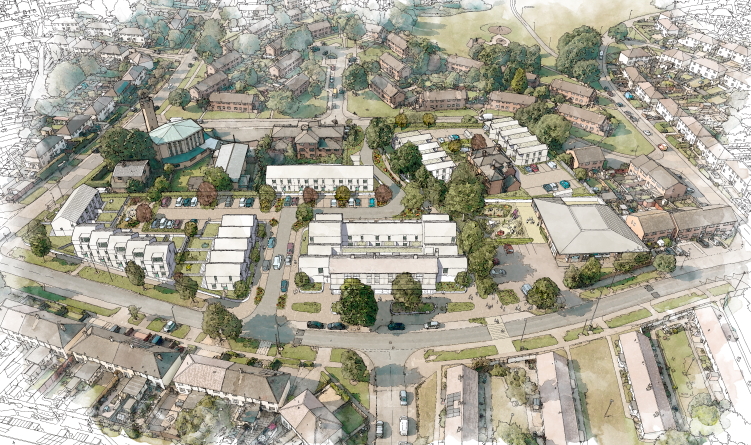
The proposals look to balance the needs for new council housing with
the existing community's needs. The first phase has already
commenced by turning the former youth centre into a new Community
Shop, a community cafe open to everyone and a Community Zone
(indoor community space available to hire).
Some of the existing buildings which are either underused or of poor
quality will need to be removed, including the community hall,
Healthy Living Centre, garages and Best One & Social Club.
The Multi-Use Games Area, whilst well-used in its current location,
will not be ideal for residents when surrounded by new housing due
to noise issues. We are currently considering other nearby sites for
a new ball court facility to replace the current court.
info Click the button below to show the existing uses on the map, and to see what will happen to them! Click on the map markers for more information on the proposals.
(Click on the button above to see these features on the map)
| Existing shops and flats to be retained | |
| Existing buildings to be re-used and refurbished | |
| Existing buildings & uses proposed for removal | |
| More information about the proposals |
The proposals include:
The Stocking Farm Neighbourhood Centre development aims to achieve
high environmental standards.
We aim to reduce the site's carbon footprint and reduce the overall
reliance on unsustainable fossil fuels (e.g. coal, petroleum,
natural gas).
The proposals aim to retain and enhance our natural and green
environment by keeping existing trees (where possible) and designing
landscapes that create wildlife habitats.
info Click on each of the information markers to find out more about these elements and to see what we are proposing.
Our approach to re-imagining the Stocking Farm Neighbourhood Centre
was to keep as much we could and only build new where necessary.
The parade of shops and the 5 existing flats above it will be
improved, keeping shopping local and convenient.
Where existing buildings are being removed, we plan to salvage
materials and re-use them on-site wherever possible to avoid the
energy and cost of lorries taking materials away.
The existing footpath will be re-surfaced and re-lit to feel safer.
New footpaths will link homes to a new pedestrian-friendly road to
promote walking and cycling rather than car use when travelling
locally for short journeys.
| Building design | |
| Landscaping | |
| Transport & connectivity | |
| Existing bus routes (to remain) | |
| Illustrative path of the sun |
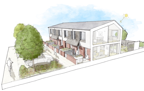
All new homes at Stocking Farm will be council homes, providing for
a mixture of families of different sizes and residents with some
more specialist needs in-line with the council's housing needs for
the area.
The houses and flats are designed to the latest National Space
Standards, meaning that rooms are good sizes, are flexible in how
they can be furnished and have ample space for storage.
Inside, they will be bright and daylit with generous windows looking
out onto a private garden, or balconies where flats have been
proposed. Most homes will have a modern open plan kitchen/dining
area with a separate living space. Upstairs bedrooms share a
good-sized family bathroom.
info Click on the map markers to view street view sketches of the proposals, and to find out more about the houses.
We've given lots of thought to making these homes warm and
comfortable with new heating systems whilst keeping energy bills
down as low as possible.
They will have lots of insulation in the walls and roof, and triple
glazed windows – to contain the heating residents use, for warmth.
Air Source Heat Pumps (ASHP) sit outside the house (instead of a gas
boiler inside) and draw warmth from the outside air to provide hot
water and heating inside.
A simple ventilation system provides fresh air but does not waste
heat to the outside. Rooftop solar panels on all of the south-facing
roofs will help to reduce electricity costs further.
On the outside, homes will be in keeping with the area, made with a
mixture of familiar new and reclaimed materials-brick, tile, render
and wood with coloured doorways to distinguish each home.
Houses are separated from the pavement by a low wall and a front
gate with recycling, bin storage and a space for the air source heat
pump in front of the house.
| Street view sketches of proposed house designs | |
| More information about the houses |
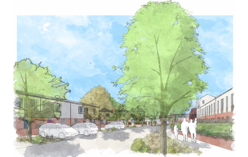
Inspired by the existing green verges along road edges that
characterise Stocking Farm, new footpaths will have soft planted
borders and new trees to create a pleasant green environment and
strengthen local wildlife habitats.
Low-level garden walls to the terraced houses will help create a
sense of openness whilst ensuring the well-lit streets and pathways
are observed and feel safe for residents, whilst helping to maintain
a sense of privacy.
New main stairwells will be constructed for the new and existing
flats off Marwood Road to provide a safe and well-lit access for
residents. Secure bike storage will be provided onstreet for these
flats.
info Click the button below to highlight all proposed car parking spaces on the map! Click on the map markers to find out more about the streets.
Careful consideration has been given to parking, attempting to
balance the needs of the residents and local community whilst
creating a pleasant, safe environment to walk through and live in.
The new central road will contain several parking bays along its
length. Additional residents parking will be located within a
landscaped area north of St. Luke's Church Hall.
Community open space - a new outdoor community space next to the
Community Zone - will be created, with designs to be developed with
the community for a playground aimed at younger children
(2-8 years), seating and a small community garden and wildlife area.
A new pedestrian crossing along Marwood Road, connecting to the
public footpath towards the school creates a safe location for the
residents to cross to get to the community space and shops.
| Proposed Outdoor Community Space | |
| Improved footpath | |
| Proposed pedestrian crossing | |
| Proposed central road | |
| Proposed car parking | |
| Street view sketch of new central road | |
| More information about the streets |

You can now complete a short quiz to test everything you have learnt today about the proposed regeneration of Stocking Farm.
If you need any help, you can always refer back to the information on this webpage, or you can ask your teacher.

An
Engaged Space community engagement on behalf of Leicester City Council.
Powered by
Deetu.
Got a story to tell?
Get in touch.

Welcome to this digital case study of the proposed regeneration of
the Stocking Farm Neighbourhood Centre, created on behalf of
Leicester City Council for the students of Babington Academy.
This website will guide you through what we learnt from the
public consultation, our initial proposals for the Stocking Farm
Neighbourhood Centre, and will then ask you to complete a short
quiz at the end.
Who is undertaking this engagement?
This digital case study was created on behalf of Leicester City
Council. All feedback from this quiz will be anonymous, and
it may be used as planning evidence. Please don't provide any
personal or identifying information in your quiz answers.
Each section of this website has a descriptive map key in the
main menu, with hints to let you know about any interactive
features on the map.
Once you reach the end of the website, we will ask you to complete
a short quiz about Stocking Farm Neighbourhood Centre. Your
views really matter to us.
You can pan, zoom and tilt the map to fully explore Stocking
Farm Neighbourhood Centre.
Stocking Farm Introduction
Welcome to the third stage of Leicester City Council's community
engagement for the proposed regeneration of the Stocking Farm
Neighbourhood Centre. This website will guide you through what
we learned from the first two stages of community engagement,
our initial proposals for the Stocking Farm Neighbourhood
Centre, and then ask you to complete a short survey at the end.
History of Stocking Farm
From our previous consultation responses, many of you mentioned
that you have vivid memories of how Stocking Farm used to be.
Did you know that St. Luke's Church was built over several years
by members of the local community, with construction starting in
April 1961?
Watch the above historical maps to see Stocking Farm
through the ages and explore this page further by clicking on
the photo icons to see fascinating historical images of the
Stocking Farm Farmhouse, the former Stocking Farm Youth Centre
and St. Luke's Church.
You said, we did
In our last stage of public engagement in October 2021, you told
us what was most important to you regarding the regeneration of
Stocking Farm Neighbourhood Centre. We have listened to your
feedback and have used it to inform our proposals. Click on the
map markers to find out more about our plans.
Latest proposals for the site
Building on earlier community feedback, neighbourhood facilities
are focused around the former Youth Centre, creating the
community shop, an indoor community space and an outside space
that will be designed with the community in the next stage.
A pedestrian crossing and improved footpath runs alongside the
community open space and is lined with trees and areas of
planting.
The back of the existing shops will be wrapped by homes with
windows overlooking a pedestrian friendly street that winds
downhill between Marwood Road and Packwood Road.
The Farmhouse will be converted and renovated into flats flanked
by two residential buildings and set in a garden landscape.
Terraces of family houses are arranged along Halifax Road,
Marwood Road and along the street, opening up the middle of this
under-used part of Stocking Farm to make a pleasant and green
setting for a new part of the community.
Environmentally Friendly
The Stocking Farm Neighbourhood Centre development is aiming to
achieve high environmental standards. We're aiming to not only
reduce our carbon footprint, but reduce our overall reliance on
unsustainable fossil fuels, for example, coal, petrol and
natural gas.
The proposals aim to retain and enhance our natural and green
environment by keeping existing trees wherever possible, and
designing landscapes that create new wildlife habitats.
What will the houses look like?
All of the new homes at Stocking Farm will be council homes
seeking to meet the council's housing needs for the area. They
will provide for a mixture of families of different sizes and
residents with some more specialist needs as well.
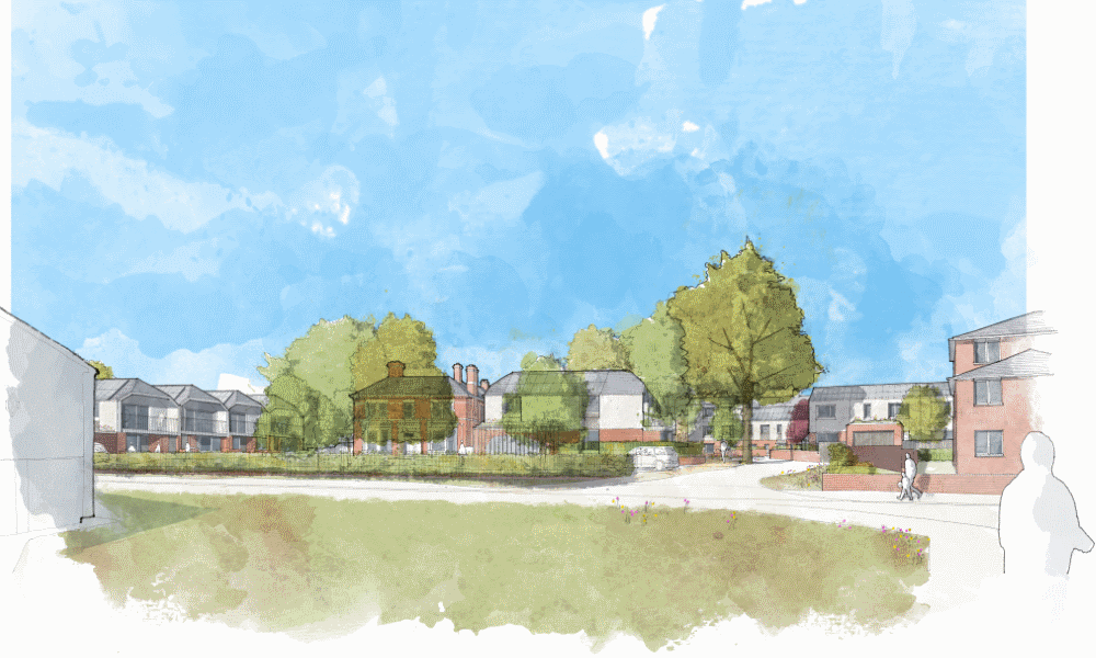
Explore these 3D views to see what the Stocking Farm
Neighbourhood Centre proposals could look like from Packwood
Road, Marwood Road and the proposed new central road.
What will the streets look like?
A new street of terraced houses wind through the middle of
Stocking Farm behind the retained existing shops. The shape of
the street naturally calms traffic and has new street trees and
landscaping that will improve biodiversity and make a pleasant
setting for the new homes and community.
Houses overlook the new street from both sides, encouraging
natural observation and fostering a sense of safety. The
existing trees will be kept and the footpath through the site
improved alongside a new community open space that will provide
great new facilities for young and old.
This website is to be used as a consultation tool
only and not for architectural or design purposes. Buildings,
sites and features are represented as approximations of their
true dimensions and the map does not account for terrain.
The data within the model is derived from a variety of open data
sources and we thank the organisations attributed below for its
provision.
| Data Source | License |
|---|---|
| OS Open Data | Contains Ordnance Survey data © Crown copyright and database right . |
| OpenStreetMap Contributors | Contains OpenStreetMap data and derived data licensed under the Open Database Licence. |
| CentremapsLive | Historic Ordnance Survey maps (1915, 1952, 1993) republished here with license and permission. |
| National Library Scotland | Historic maps (1899, 1904, 1930) republished here with license and permission April 2022. |
An Engaged Space community engagement on behalf of Leicester City Council and actively maintained by Deetu. To find out more, please get in touch.
Skip straight to the frequently asked questions of interest by clicking one of the themes below, or continue scrolling this page to read them all.
1. General
Why is this project happening in Stocking Farm?
The City Mayor Sir Peter Soulsby has said:
"Many parts of Leicester, including Stocking Farm, were shaped
by the Council in the 20th Century. It is now time to revisit
these sites and ensure they are fit for purpose in the 21st
Century...we would like to engage with the local community to
explore opportunities and shape a vision that will bring
unused land and property back into use, improve life for local
residents and help kickstart the regeneration of this
important part of the city Government funding has been awarded
to support the development of this vision."
2. Have your say
I know somebody who does not have access to the internet and would like to take part in this public engagement. How can they have their say?
Now that COVID 19 restrictions have eased they can either:
3. Engagement
Will people from other parts of the city be able to have a say about future plans for my area? Who has been invited to take part in this public engagement?
The geographical area of engagement is focused in the local Stocking Farm area. However, other residents who live in other parts of the city are welcome to complete this survey if they wish to, this includes people who may previously have lived in the area, or currently make use of retail or community facilities or work in the area. We are keen to hear the views of the people who know and use the area. This is why we collect postcode information to be able to help analyse whether the people commenting are from the area.
4. Memories
I have some memories and/or old photos I'd like to share with you. How can I get these to the council?
We would love to hear your memories from the area! We are keen to collect images of the area to be able to share them with other members of the local community in the future. If you have anything you'd like to share, please email: development-team@leicester.gov.uk or call officers on 0116 454 2902.
5. Stocking Farm Newsletters
The website mentioned newsletters. I haven't received copies through my door and yet I am a resident in the local area. How can I see copies?
The council have delivered four different newsletters to 2,200+
local addresses (residents and stakeholders) in March, August,
and December 2021 and again in February 2022. These featured
updates on the project, activities in the area and Community
Shop updates.
If for any reason you have not received a copy, please email
development-team@leicester.gov.uk
requesting electronic copies or call officers on 0800 170 1223.
Alternatively, you can download all four copies from this
website here or view them in person at Community Shop:
Download Stocking Farm Newsletter - Issue 1
Download Stocking Farm Newsletter - Issue 2
Download Stocking Farm Newsletter - Issue 3
Download Stocking Farm Newsletter - Issue 4
6. Community Shop
It's great to hear about the new Community Shop, will I be able to become a member?
Community Shop is now open providing discounted food for members
and a community café for everyone. The Community Zone will
provide a new indoor space for people and groups to hire.
To become a member, if you meet the membership criteria, you can
either pop in to the shop to sign-up or
follow this link.
Alternatively, you can follow them on Facebook at this link:
www.facebook.com/communityshopscic
7. Indoor community Space
Will the existing Community Hall still be available to use?
No, the building has been closed during the COVID-19 period.
The building would require substantial financial investment to
repair it in order to open it again to the public.
Having engaged with Community Hall user groups they have
preferred the option to invest in one, better community space
within the new Community Shop. The new Community Zone is
available to hire. Please contact hello@community-shop.co.uk to
make enquiries about booking the new space.
Will the Healthy Living Centre still be available to use?
No, the building has been closed during the COVID-19 period.
Although this is a more modern building there have been a number
of issues with it for some time which would require substantial
financial investment to fix.
Having engaged with some of the Healthy Living Centre user
groups they have preferred the option to invest in one, better
community space within the new Community Shop. The new Community
Zone is now available to hire. Please contact
hello@community-shop.co.uk to make enquiries about booking the
new space.
8. Outdoor community space
What will happen to the existing multi-use games area (MUGA)/ball court on the site?
The Multi-Use Games Area (MUGA), whilst known to be well-used in the current location, when surrounded by new housing, will not be ideal for residents due to noise. Other nearby sites are currently being considered for a new ball court facility to replace the current court.
9. New council homes
Who will live in these new council homes?
Tenants will be selected from the City Council's current Housing Register, as is the case with any other council homes in the city.
Will current tenants need to move out whilst the development work is carried out?
No decisions have been made yet in regard to the future of the current homes on the site. The council's housing team will meet with its tenants to identify their current needs and will also make sure any development happens as smoothly as possible.
You propose that the refurbished Stocking Farm Farmhouse and some of the new housing will be homes for people with care and support needs. What does this mean?
These will be homes for adults who, with some care and support provided, are able to live independently in the community. This is similar to a number of existing homes in Stocking Farm, such as Harrison Court on Packwood Road.
Will the old Stocking Farm Farmhouse building be retained?
Yes. This building dates back to the late 19th century and is locally listed. It is one of the few historic buildings left in this area. The council proposes to retain and convert the building into flats. Take a look at some old images of the building on this website.
How will the proposed homes be environmentally friendly?
We are hoping to make any new homes in this area of Stocking
Farm as environmentally friendly as possible. We would like
energy costs to be cheaper for the tenants which is why we are
proposing to move away from gas powered heating to more
sustainable/renewable energy sources such as air source heat
pumps, high levels of insulation, solar panels, orientation of
homes and gardens (to maximise benefits from the sun's heat and
light) etc. See the pages ‘Environmentally Friendly' and ‘What
will the houses look like?' for further information.
After our Stage 1 of public engagement, we ran a competition
with local schools for pupils to design what they think a house
of the future looks like. The winners can be found on our
Stage 2 engagement website here.
They had some inspiring ideas!
How has the housing mix been decided?
The proposed housing mix has been designed based on the council's housing register, which shows there is a critical need for a mix of homes from 1 bedroom flats to 4 bedroom houses.
10. Shops
Will the Marwood Road parade of shops be knocked down?
No, in the first stage of public engagement in January/February
2021 the community told us that its priorities (for retail) were
for a convenience store, post office and fast-food takeaway.
This was re-confirmed in our stage two engagement in
October/November 2021.
The Marwood Road retail block is a traditional 1960's concrete
building, typical of those across the city. The production of
concrete is one of the most harmful techniques that damages the
environment.
To remove this building would lead to large and unnecessary
amounts of carbon emissions. Given that the structure of the
building is in relatively good state of repair, we are proposing
to retain the main block (and 5 maisonettes above) and make
improvements.
To make the most of the building it is proposed that the single
storey elements (containing a vacant unit, and the funeral
directors, who we are working with to re-locate) are
knocked-down, new stairwells are created, and new flats are
added at either end of the building.
See
this section of the website for details.
Will Best One (and Post Office) and the Social Club remain?
he council proposes to build around 50 new much needed council
homes which means we will need to work with local residents and
stakeholders to prioritise the uses on the site that matter most
to you.
So far, we have heard that a convenience store and fast food
take away matter most to the community and that a majority of
residents live to the west of the existing shops. Local
residents also indicated which facilities they use least on the
site.
Taking all of this into consideration we propose to concentrate
the shops (including a convenience store and fast-food takeaway)
in the existing building close to the new Community Shop. We
propose that the land on the corner of Marwood Road and Halifax
Drive is redeveloped for new homes.
Having purchased this site in 2021 to help deliver these
proposals, we are in discussions with the tenants of Best One
and the Good Old Days social club. The community also told us
that a post office was important. We are currently considering
all options to ensure this service is provided within the new
re-development.
11. Neighbourhood Management
Will the proposals do anything to reduce the current levels of anti-social behaviour?
Our intention is that our proposals for the Neighbourhood Centre will remove a lot of unused or underused land and buildings and mean that the area is safe and more open and accessible. Our experience is that more people walking in and using an area, as well as housing tenants overlooking an area means more surveillance and visibility and therefore less anti-social behaviour. A first step has already been taken with the opening of the Community Shop in the former youth centre building.
12. Garages
I currently rent a garage on the site; will I be able to do this in the future?
Our proposals include for the garages to be demolished in order to create space for much needed new council homes and to remove a magnet for anti-social behaviour. Should these proposals secure planning permission then the council will serve the required notice period on occupiers to vacate their garages of their belongings. Before doing this, we will share details of other local council and private storage facilities.
13. Footpath
Will the footpath from Packwood Road to Marwood Road remain?
Yes, in our first phase of community engagement many of you told us that you would like to keep the footpath open. We are proposing to improve the route so that it feels safe for everyone to use, and also plan to add in a new road crossing linking in Marwood Road with Blenheim Way to ensure connections in the area are improved further.
Are any trees proposed to be cut down?
No decisions have been made at this stage. In line with the
environmental standards we are hoping to achieve the council
would prefer to keep as many trees as we can. The council has
carried out tree surveys already to assess their quality/safety.
It is recognised that there are some large, mature trees in the
area, which provide important habitats for wildlife, as well as
providing areas of shade. If we do need to remove a small number
of trees, we will plant replacements and additional trees, where
possible. A landscape architect and ecologist are advising on
the proposals to ensure they are as environmentally friendly as
possible.
Are there any proposals to improve ecology in the area?
The council would like to improve the ecology in the area. We are proposing new street trees, additional landscaping, sustainable drainage (which could provide additional habitats) and generally encouraging wildlife. A landscape architect and ecologist are advising on the proposals to ensure they are as environmentally friendly as possible.
14. Getting Around
Where will cars be able to park?
The development must comply with the council's Parking Strategy
(planning policy) to ensure there are enough parking spaces
provided for the shops, community space, residents and visitors.
The Community Shop has already met its requirements through
their planning application and will share the car parking spaces
already in place next to the Marwood Road shops, which we
propose to improve.
Our phase 1 engagement showed that most
people walk to the shops and community uses. Any new homes will
be designed with adequate parking to meet the Parking Strategy
and the appropriate transport surveys will be carried out as
part of any planning application. We will also be looking to
include space for cycle storage in new homes so that people can
have the choice to consider making short journeys by bike rather
than by car.
You can look at:
www.choosehowyoumove.co.uk
to find easy ways to plan your journey as an alternative to car
use, such as public transport, walking or cycling.
I am a cyclist. How are my needs being addressed?
Cycle storage will be designed into the housing in line with the
current planning policy requirements. Outdoor secure and safe
storage is also being planned for those living in flats.
We are currently considering proposals to provide a Santander
e-bike hire hub within the scheme, like those you may have
already seen in the city centre. As the scheme is rolled-out
across the city there will be more hire and drop-off points
available, making e-bike hire an attractive option for shorter
journeys. More information on the scheme can be found here at
www.santandercycles.co.uk/leicester.
The council also runs training programmes for those wanting to
learn to ride, or simply improve their skills and confidence on
the road. More information can be found here at
Leicester City Council cycle training for adults.
Will the bus routes change?
We have no proposals to change the current routes or bus stops.
Existing bus stops will remain in place on Marwood Road and
Halifax Drive.
You can look at
www.choosehowyoumove.co.uk to
find easy ways to plan your journey as an alternative to car
use, such as public transport, walking or cycling.
We respect your privacy and are committed to protecting your
personal data.
All feedback is being collected on behalf of Leicester City Council.
In accordance with our Privacy Policy,
responses will be shared with Leicester City Council and their professional advisors as part of the statutory
consultation process.