


-01.png)

The initial consultation is now closed.
Mae'r ymgynghoriad cychwynnol bellach ar gau.
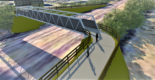
Welcome to the community engagement for the potential construction of a new shared use (pedestrian/ cyclist) bridge crossing the railway line in Llanelli.
Croeso i'r digwyddiad ymgysylltu â'r gymuned ar gyfer y posibilrwydd o adeiladu pont newydd a rennir (cerddwyr/beicwyr) sy'n croesi'r rheilffordd yn Llanelli.
This interactive document will guide you through the site and ask for
your thoughts on the scheme through a short survey.
We are seeking your views as the new bridge and adjoining links are
due to be put forward for Active Travel funding in 2022/2023.
Bydd y ddogfen ryngweithiol hon yn eich arwain drwy'r safle ac yn gofyn
am eich barn ar y cynllun drwy arolwg byr.
Rydym yn gofyn am eich barn gan y bydd y bont newydd a'r cysylltiadau
cyfagos yn cael eu cyflwyno ar gyfer cyllid Teithio Llesol yn 2022/2023.
info Look out for blue highlighted text like this - it will indicate interactive features on the map.
info Cadwch lygad am destun glas fel hwn - bydd yn dangos nodweddion rhyngweithiol ar y map.
| Proposed bridge location |
| Lleoliad y bont arfaethedig |
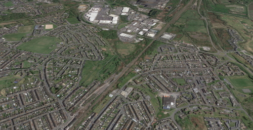

The bridge forms part of a wider series of plans to create a high quality continuous active travel network throughout Llanelli with a particular emphasis on the Llanelli Spinal route that will eventually connect Hendy in the North to the Pentre Awel development and Millennium Coastal Path in the South. The route will also help to connect all communities and key destinations in-between.
info This is being referred to as the Llanelli Spinal Route and a video showing more can be seen on the map.
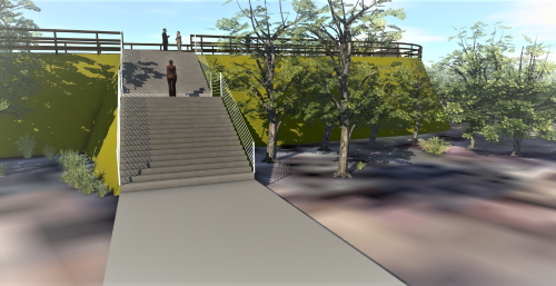
The replacement bridge will allow all users, including those that are disabled, along with those travelling with prams/buggies to access the traffic free path that leads up through the former Pen-y-fan quarry and ongoing links to key destinations such as Trostre Retail park, Llanelli railway station and to Halfway (once the A484 shared use bridge is built) as well as connect South to works done previously.
Mae'r bont yn rhan o gyfres ehangach o gynlluniau i greu rhwydwaith teithio llesol parhaus o ansawdd uchel ledled Llanelli gyda phwyslais arbennig ar brif lwybr Llanelli a fydd yn y pen draw yn cysylltu'r Hendy yn y Gogledd â datblygiad Pentre Awel a Llwybr Arfordirol y Mileniwm yn y De. Bydd y llwybr hefyd yn helpu i gysylltu pob cymuned a chyrchfannau allweddol yn y canol.
info Cyfeirir at hyn fel Prif Lwybr Llanelli a gallwch wylio fideo sy'n dangos mwy yma.
Bydd y bont newydd yn caniatáu i bob defnyddiwr, gan gynnwys y rhai sy'n anabl, ynghyd â'r rhai sy'n teithio gyda phramiau/bygis gael mynediad i'r llwybr di-draffig sy'n arwain i fyny drwy hen chwarel Pen-y-fan a chysylltiadau parhaus â chyrchfannau allweddol fel parc Adwerthu Trostre, gorsaf reilffordd Llanelli ac i Halfway (ar ôl i'r bont 'rhannu defnydd' ar yr A484 gael ei hadeiladu) yn ogystal â chysylltu'r De â gwaith a wnaed o'r blaen.
| (Black Bridge) Proposed bridge location | |
| Existing active travel route | |
| (A484) Proposed bridge location | |
| Llanelli Spinal Route video |
| (Bont Ddu) Lleoliad y bont arfaethedig | |
| Llwybr Teithio Llesol presennol | |
| (A484) Lleoliad y bont arfaethedig | |
| Prif Lwybr Llanelli fideo |
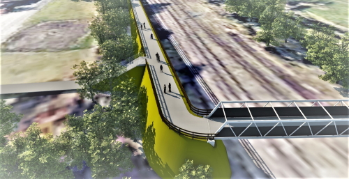

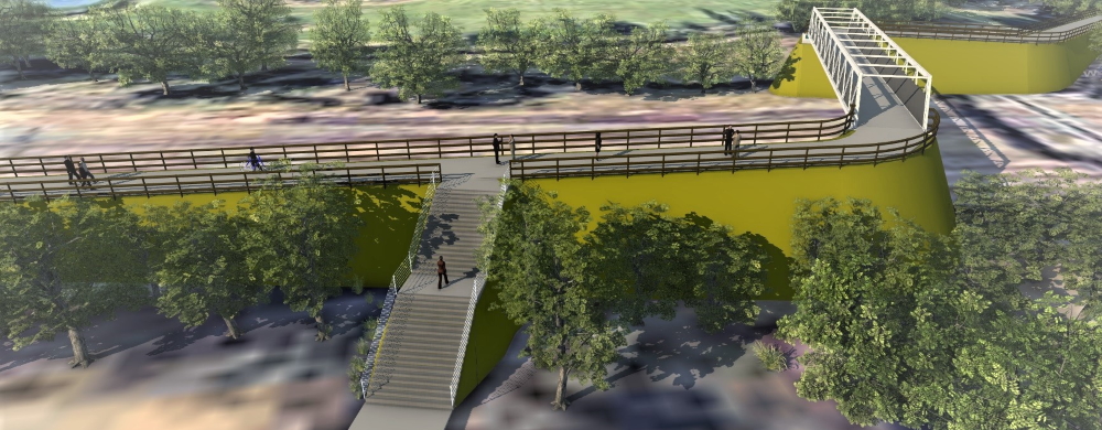
The design of the bridge has been developed with feedback from Network
Rail and is fully complaint with Active Travel guidelines.
This will include a non-slip waterproof surface and extended heigh
parapet along its length.
Paths leading to and from the bridge will also be well lit for enhanced safety.
info Detailed designs for the bridge can be viewed by clicking the appropriate links shown on the map.
Dyluniwyd y bont drwy ystyried adborth gan Network Rail ac mae'n
cydymffurfio'n llwyr â chanllawiau Teithio Llesol.
Bydd hyn yn cynnwys arwyneb gwrth-ddŵr di-lithr a pharapet uchel
estynedig ar ei hyd.
Bydd llwybrau sy'n arwain at ac oddi wrth y bont hefyd wedi'u
goleuo'n dda er mwyn gwella diogelwch.
info Cliciwch ar y marcwyr ar y map i weld dyluniadau manwl ar gyfer y bont.
| Proposed bridge location | |
| Bridge design images |
| Lleoliad y bont arfaethedig | |
| Delweddau o ddyluniad y bont |

The initial consultation is now closed - but comments and suggestions are still welcome.
Mae'r ymgynghoriad cychwynnol bellach ar gau - ond mae croeso o hyd i sylwadau ac awgrymiadau.
Thank you for taking the time to explore the potential development. We would love to hear your thoughts.
Diolch ichi am gymryd yr amser i archwilio'r datblygiad posibl. Hoffem glywed eich sylwadau.
Initial consultation will end on Sunday 23rd January, but comments and suggestions are welcome after this period.
Bydd yr ymgynghoriad cychwynnol yn dod i ben ddydd Sul 23 Ionawr, ond mae croeso i chi gyflwyno sylwadau ac awgrymiadau ar ôl y cyfnod hwn.
info You can also click on the map marker to access the survey.
info Gallwch hefyd glirio ar farciwr y map i gael mynediad i'r arolwg.
| Survey marker |
| Farciwr y arolwg |
-01.png)
An
Engaged Space community engagement on behalf of Carmarthenshire County Council.
Powered by
Deetu.
Got a story to tell?
Get in touch.
Llwyfan ymgysylltu cymunedol,
Engaged Space, ar ran Cyngor Sir Caerfyrddin.
Cynhelir gan
Deetu.
Oes gennych chi stori i'w hadrodd?
Cofiwch gysylltu.

The initial consultation is now closed - thank you to everyone who submitted responses during the consultation period. Comments and suggestions are still welcome.
Mae'r ymgynghoriad cychwynnol bellach ar gau - diolch i bawb a gyflwynodd ymatebion yn ystod y cyfnod ymgynghori. Rydym yn croesawu sylwadau ac awgrymiadau o hyd.
Welcome to the community engagement for the potential construction
of a new shared use (pedestrian/ cyclist) bridge crossing the railway
line in Llanelli.
This new bridge will replace the existing structure currently known
as Black Bridge whilst also enhancing the attractiveness of the immediate
area.
This interactive document will guide you through the site and
ask for your feedback at the end through a short survey.
Initial consultation will end on Sunday 23rd January, but
comments and suggestions are welcome after this period.
Croeso i'r digwyddiad ymgysylltu â'r gymuned ar gyfer y posibilrwydd
o adeiladu pont 'rhannu defnydd' newydd (cerddwyr/beicwyr) sy'n
croesi'r rheilffordd yn Llanelli.
Bydd y bont newydd hon yn cymryd lle'r strwythur presennol a
adwaenir fel y Bont Ddu ar hyn o bryd, gan wella ymddangosiad yr
ardal gyfagos hefyd.
Bydd y ddogfen ryngweithiol hon yn eich arwain drwy'r wefan ac
yn gofyn am eich adborth ar y diwedd drwy arolwg byr.
Bydd yr ymgynghoriad cychwynnol yn dod i ben ddydd Sul 23
Ionawr, ond mae croeso i chi gyflwyno sylwadau ac awgrymiadau
ar ôl y cyfnod hwn.

Each section of the story has a descriptive map key in the
main menu, with hints to let you know about any interactive
features on the map.
Once you reach the end of the story, you will have a chance
to answer a short survey about the site. We would
love to hear your views!
Finished reading? Our story is fully interactive - pan, zoom
and tilt the map to fully explore the site.
Yn y brif ddewislen, mae allwedd ddisgrifiadol ar gyfer pob
rhan o'r stori, fynghyd ag awgrymiadau i roi gwybod i chi am
unrhyw nodweddion rhyngweithiol ar y map.
Ar ôl i chi gyrraedd diwedd y stori, cewch gyfle i ateb
arolwg byr am y safle. Hoffem glywed eich barn!
Wedi gorffen darllen? Mae ein stori'n gwbl ryngweithiol -
gallwch symud, nesáu a gwyro'r map i archwilio'r safle'n
llawn.
This site is to be used as a consultation tool only
and not for architectural or design purposes. Buildings, sites
and features are represented as approximations of their true
dimensions and the map does not account for terrain.
The data within the model is derived from a variety of open data
sources and we thank the organisations attributed below for its
provision.
Dylid defnyddio'r wefan hon fel dull ymgynghori yn
unig ac nid at ddibenion pensaernïol neu ddylunio. Mae'r
adeiladau, safleoedd a nodweddion yn frasamcanion o'u gwir
fesuriadau ac nid yw'r map yn rhoi cyfrif am dirwedd.
Mae'r data yn y model yn deillio o amrywiaeth o ffynonellau
data agored ac rydym yn ddiolchgar i'r sefydliadau a nodir isod
am eu darparu.
| Data Source | License |
|---|---|
| OS Open Data | Contains Ordnance Survey data © Crown copyright and database right . |
| OS Mastermap | © Crown copyright and database rights Ordnance Survey 0100031673 |
| OpenStreetMap Contributors | Contains OpenStreetMap data and derived data licensed under the Open Database Licence. |
| Ffynhonnell Data | Trwydded |
|---|---|
| Data Agored yr Arolwg Ordnans | Data'r Arolwg Ordnans © Hawlfraint y Goron a hawliau cronfa ddata . |
| OS Mastermap | © Crown copyright and database rights Ordnance Survey 0100031673 |
| Cyfranwyr OpenStreetMap | Data OpenStreet Map a data wedi'i drwyddedu o dan y Drwydded Cronfa Ddata Agored. |
An Engaged Space community engagement on behalf of Carmarthenshire County Council and actively maintained by Deetu. To find out more, please get in touch.
Llwyfan ymgysylltu cymunedol, Engaged Space, ar ran Cyngor Sir Caerfyrddin, a gynhelir gan Deetu. I gael rhagor o wybodaethe cysylltwch â ni.