


This consultation is now closed, but comments and suggestions are still welcome.
Welcome to the public consultation for the Fiddler's Ferry Development Framework. This
will explain, in a coordinated and comprehensive way, how we will redevelop the site.
The redevelopment will support thousands of new jobs. New homes will be provided with
new infrastructure required to support it. The Development Framework will explain how
we will achieve the Council's planning policy requirements for the site.
This interactive website will present the content of the draft Development Framework. It will guide you through the vision for the transformation of Fiddler's Ferry. At the end, we will ask you to complete a short survey.
Scroll this menu and look out for red highlighted text like this - it will indicate interactive features on the map.
Your views really matter to us. We are really excited to share our plans for this
transformational project with you.
We are still refining the Development Framework for Fiddler's Ferry. The thoughts of local
residents and businesses will help us shape our final document. The sections below set out
what we would like to achieve, and your views are very important to us.
The survey will close on Sunday 11th February 2024. We will use the feedback provided to
influence the final content of the Development Framework.
This document will then be formally 'agreed' by Warrington Borough Council (WBC). The
document will be used in the determination of future planning applications on the site.
Map Key
 | Wider Development Framework area |
History
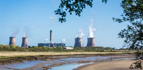
Standing on the north bank of the River Mersey, Fiddler's Ferry has been a prominent
landmark for almost half a century.
The coal-fired power station was first proposed in 1962. It was named after the nearby
Ferry Inn, standing on the site of an old ferry which once shuttled people across the
Mersey. The ferry service was discontinued in the late 19th century, but by then the
name had stuck.
Click on the map markers to view historical photos and memories from the local community.
The plant provided electricity to the National Grid for over 50 years before it reached
the end of its intended lifespan. Originally operated by the Central Electricity
Generating Board (CEGB), the power station was subsequently owned by several companies.
This was until SSE bought it in 2004 and operated it until its closure in March 2020.
In July 2022, Peel NRE acquired the site, intending to redevelop it for new employment
and housing.
Peel's vision for the site reflects that it has been allocated in the recently-adopted
Warrington Local Plan. It includes 101 hectares of employment land, which will support
thousands of jobs. This will be in addition to a minimum of 860 homes. Supporting
infrastructure will include a primary school, local centre, and potential GP surgery.
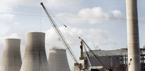
The four northern cooling towers were successfully demolished in December 2023. Demolition
and clearance works are continuing on-site, with the administrative buildings now gone. The
breaking out of the former coal pad area is well underway. You can find more details of the
demolition on
Map Key
| Wider Development Framework area |
 | Historic photographs of the site courtesy of SSE and our contributors |
 | Contributors' memories of Fiddler's Ferry |
Previous Consultation
In November 2022, we consulted on the first phase of redevelopment at Fiddler's Ferry. This
focused on the former coal stockyard.
This first phase will provide 1.4 million sq ft of high-quality employment development across
four buildings. This will bring jobs back to the site.
Feedback from that consultation informed the preparation of a planning application.
Peel NRE submitted this application to WBC in March 2023 and is pending determination
(WBC ref. 2023/00392/EA).
Click on the map markers to read some of the comments we received from the local communities during the first stage of consultation.
This application is just the first phase of transforming the former power station. Creating
new jobs will help to ensure local people have options for work. New employment will enhance
the prosperity of Warrington and Widnes.
We want to thank everyone who shared their thoughts with us during the previous consultation.
Map Key
 | Phase 1 Development Boundary |
| Contributors' comments from first stage of consultation |
What will happen next

Fiddler's Ferry is a once-in-a-generation opportunity to redevelop one of the largest
brownfield sites in the region. Peel NRE and WBC want to maximise this opportunity.
The Council has recently adopted their Local Plan. This requires a Development Framework
to guide the redevelopment.
The Council has identified the site as having the potential to help fulfil the future
needs of Warrington. Large parts of the site not proposed for new development remain
within the Green Belt. This includes the ash lagoons to the south of the railway line.
In the Local Plan, the site is allocated for mixed-use development. The allocation
includes providing 101 hectares of employment land. This will be in addition to a
minimum of 860 homes. Supporting infrastructure will include a primary school, local
centre, and potential GP surgery.
This consultation is for the Development Framework, covering the entire Fiddler's Ferry
site. Its purpose is to ensure a coordinated and comprehensive approach to new
development. The Development Framework takes into account all infrastructure
requirements.
The feedback from this consultation will shape our final version of the Development
Framework. This will then be submitted to WBC for formal agreement. The document will
be used in the determination of all future planning applications at any phase of
development at Fiddler's Ferry.
To view the Fiddler's Ferry Development Framework,
please click here.Map Key
| Wider Development Framework area |
| Phase 1 Development Boundary |
 | Land within Green Belt |
Our Vision
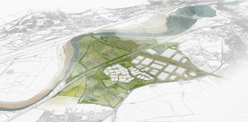
The transformation of Fiddler's Ferry will generate major new employment and
residential development. This will create mixed working and living environments
within one, distinctive new place.
We want our Development Framework to create a community with a distinct character.
The redevelopment will integrate new homes and workspace to support sustainable,
balanced lifestyles.
The map shows the draft Development Framework. Zoom into the map to see more detail and click on the map markers to find out more.
Homes and jobs will be linked to a new local centre at the heart of the community.
This will include a primary school and community uses, including space for a potential
GP surgery. There will be shops, a central parkland, and day-to-day facilities for
residents and workers.
We will provide new energy-efficient homes designed for modern living. Shared streets
and pathways will be designed to encourage walking, cycling, and road safety. These
will come together to reduce reliance on cars.
The community will benefit from an extensive new green space to encourage healthy
lifestyles. This will include parklands and equipped and informal play areas. There
will be new playing fields, including two sports pitches.
We will create two new access roads. The first will primarily serve the employment
part of the site and will be off Widnes Road to the west. The second, which will
primarily serve the new homes, will be from Marsh Lane.
The existing junction with Widnes Road will be improved to serve the early phase of
employment development. We will then adjust it to provide suitable access to the
whole development.
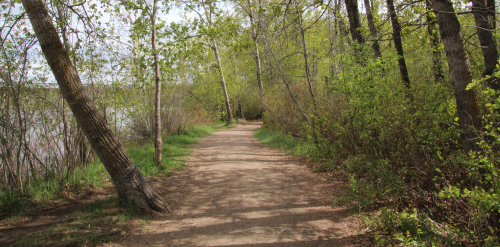
We will create links with existing public rights of way, including a link to the
Trans-Pennine Trail via Station Road. This will allow easy access to nature, open
spaces and play areas for new and existing residents.
The western part of the site will host new employment development. This could create
up to 6,750 new jobs in a variety of roles. This will ensure the site contributes to
the prosperity of the area and remains a key local employment area.
The operation of ash extraction will continue, from the lagoons to the south of the
canal and railway line. Once complete, we will restore and improve the lagoons for
wildlife and recreation.
The new planting and landscaping will encourage nature conservation. New landforms
will create permanent habitats. This will improve the biodiversity of the area. This
will be a space for new residents, and others from Warrington or Widnes, to enjoy.
The following sections explore our vision in more detail.
To view the Fiddler's Ferry Development Framework,
please click here.Map Key
| Wider Development Framework area |
| Proposed development areas | |
 | Employment development parcels |
 | Residential development parcels |
 | Mixed use local centre (indicative location) |
 | Primary school (indicative location) |
 | Rail facility |
 | Existing ash extraction operational area |
 | Existing Ash Processing Plant (retained during early phases of development) |
 | Potential new sub-station (indicative location) |
| Proposed green space network | |
 | Fiddler's Ferry nature reserve |
 | Landscape corridors and open spaces |
 | Potential for additional green corridors and open spaces |
 | Landscape enhancement along Vyrnwy Aqueduct |
 | Existing lagoon area |
 | Retained semi-natural green space |
Delivering New Employment
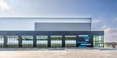
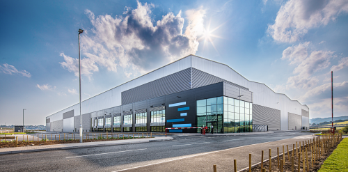
The brownfield land of the former power station has been identified for reuse. This will provide modern premises for manufacturing and logistics businesses. Businesses are needing more energy-efficient, purpose-built premises to operate in.
Click on the map markers to read more about our vision for the employment development areas at Fiddler's Ferry.
There is a shortage of these modern premises in the area and across the country. These
spaces are required to meet the needs of the economy. We want to provide opportunities
to keep local businesses in the area.
We are proposing new units in a wide range of sizes to meet demand. These opportunities
will help existing local businesses expand and attract new companies to the area.
We have submitted an application for the initial phase of the employment development to WBC.
This would support around 2,250 jobs. It represents roughly one third of the employment
space included in the Development Framework.
The remaining two thirds is expected to support a further 4,500 jobs on site. In addition,
the new local centre and community uses will create new jobs.
The 11-year phased delivery of the redevelopment will support new construction jobs. This
will create an estimated 300+ jobs in the construction sector and its supply chain.
We will create a green buffer between the employment and residential areas on site. This
will provide a separation between uses and an attractive, green boundary for the new
community.
To view the Fiddler's Ferry Development Framework,
please click here.Map Key
| Wider Development Framework area |
 | Click for more information |
 | Employment Phase 1 (operational) |
 | Employment Phase 2 (operational) |
 | Employment Phase 3 |
 | Indicative green space |
 | Green space creation / enhancement |
 | Key on-site multi-modal access routes |
| New access road towards existing bridge | |
| Bus connectivity through to residential phases |
Sustainability and Open Space
Our plans include the demolition of the former power station, which began in December 2023.
This will secure us the opportunity to redevelop one of the largest brownfield sites in the
region.
We will recycle materials including the ash extracted as part of the restoration of the ash
lagoons. This will reduce the need for primary aggregates. New, more sustainable forms of
development are important if we are to reduce the UK's carbon emissions. Our plans will look
to incorporate methods to achieve this.
Click on the map markers to read more about our vision for sustainability and open space at Fiddler's Ferry.
The buildings and homes will use the latest methods and materials to reduce carbon emissions
from construction. The buildings in our Phase 1 employment application will have a minimum
"Very Good" BREEAM rating. This will be the minimum requirement for the remaining employment
buildings in subsequent phases.
A wooded area, often referred to as a nature reserve, is on the north-eastern edge of the site
next to Widnes Road. We want to enhance and integrate this valuable space into the development.
This is despite it not being an officially designated ecological site.
This space creates a green barrier between the proposed homes and Widnes Road. We will enhance
habitats to encourage more wildlife and biodiversity. We will open the space up to public access.
A large central parkland will run through the heart of the community. This will connect the
reserve in the north to the community sports provision in the south. With the Local Centre at
the heart of the community.
Additional green corridors will provide an extensive network of green space. These will run
through the centre of the site, separating jobs and homes. They will follow the eastern edge
of the site and the southern edge along the rail lines to Station Road.
This green network will provide sustainable drainage solutions to prevent flooding. Wildlife
will be able to move safely around the built-up areas. It will ensure a suitable boundary to
the neighbouring Green Belt to the east. These spaces will ensure more recreation opportunities.
The ash lagoons in the south of the site need to have the ash extracted before we can restore
them. This process has begun and will take years to complete. In those areas without ash, work
can begin to enhance the natural environment. This will help increase biodiversity and wildlife.
The long term goal is to create a space that will be ecologically valuable. Something that will
complement the habitats within the Mersey Estuary SPA.
We will agree future restoration of the lagoons by preparing a Lagoon Management Plan. This is
a working programme that restoration has to follow for extraction of ash. The plan is an
existing requirement at Fiddler's Ferry.
To view the Fiddler's Ferry Development Framework,
please click here.Map Key
| Wider Development Framework area |
| Click for more information |
| Mixed woodland (existing and potential new) |
 | Parklands and accessibile semi-natural spaces |
 | Other semi-natural spaces |
 | Species rich grassland |
 | Wet meadow |
 | New / enhanced wildlife ponds |
 | Potential SuDS feature |
 | Hedgerow |
 | Recreational pitches |
 | Residential development |
 | Employment development |
 | Local Centre |
 | Primary School |
 | Productive communal gardens |
 | Green streets including SuDS |
 | Integrated watercourse |
| Existing ash extraction area |
 | Existing aqueduct corridor |
 | Existing lagoon area |
Connectivity
We will plan the future development around a well-connected place. It will have three access
points for vehicles from Widnes Road and enhanced public transport. Improved bus services will
link the site with Widnes and Warrington town centres.
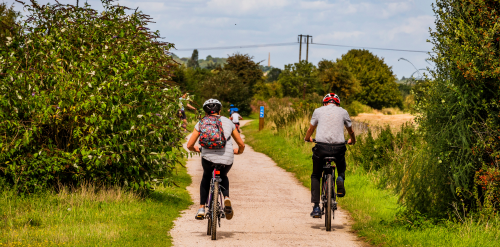
We will support active travel via a network of multi-user routes and segregated foot and
cycleways. These will run throughout the site and link to surrounding footpaths.
Click on the map markers to read more about our vision for creating new connections around Fiddler's Ferry.
Currently, the only site access is at the junction with Widnes Road. This will be improved to
serve the early phase of employment development. We will then adjust it to provide suitable
access to the whole development. This will improve how vehicles filter towards either the
employment or residential parts of the site.
We will create two new access roads. The first will primarily serve the employment part of the
site and will be off Widnes Road to the west. The second, which will primarily serve the new
homes, will be from Marsh Lane.
The roads through the residential area will be shared spaces, to encourage use by pedestrians
and cyclists.
We will create a series of new green corridors across the site. These more natural routes will
allow people to walk and cycle off the roads through the site. Another benefit is they will act
as wildlife corridors and connect habitats around the area. These routes will link to the site
boundary and the land around the site. This will open the site up for existing communities in
Widnes and Warrington.
The Trans-Pennine Trail runs along the Sankey Canal. The new community will be able to access
the Trans-Pennine Trail using a new path to Station Road. At this point it will cross the canal.
There is the future potential to connect the new community to the ash lagoons via the existing
road bridge. This will be subject to ongoing ash extraction operations, restoration and future
development phases.
There may be options to provide a bus and/or cycle and pedestrian link to Johnson's Lane in the
west. Plans for this potential link are being explored with key stakeholders, including WBC and
Halton Borough Council (HBC). The plans will be subject to a feasibility assessment. Peel has
recently amended the Phase 1 employment application to allow for future safeguarding of a route.
There is the potential to divert existing bus services through the Phase 1 employment area.
There is also the potential for new bus routes and services for future employment phases. These
would then integrate with the residential areas as they are delivered.
To view the Fiddler's Ferry Development Framework,
please click here.Map Key
| Wider Development Framework area |
| Primary pedestrian / cycle corridors | |
| Secondary pedestrian / cycle corridors | |
| Tertiary pedestrian / cycle connections | |
| Informal connectors (traffic-free circulatory pedestrian / cycle routes) | |
| Existing Trans-Pennine Travel (indicative) |
Housing and Community
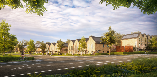
As of January 2023, there are almost 6,000 households on the Warrington housing waiting list. This
is with an average of 70 applications a week. Halton Borough has a further 4,000+ households on the
housing waiting list.
The area desperately needs new homes delivered for today and the future. Our proposals will help to
do this in a way the Council thinks is appropriate.
The Local Plan means a minimum of 860 new homes with a mix of sizes and types will be delivered.
30% of the homes will be affordable homes. The homes that will be energy-efficient and prepared for
the future.
Click on the map markers to read more about our vision for the residential areas at Fiddler's Ferry.
There will be play areas for families to enjoy, which will include parks with fully equipped play
spaces. These will be phased with the delivery of new homes.
In addition, there will be spaces for more informal play. Children living in the new homes would
have access to play areas that they can reach safely. Over 8 hectares of public open space and
two sports pitches will provide even more spaces for people to enjoy.
Communities are more than just houses. At the centre of the residential area, we are proposing a
new local centre for the community.
The local centre will include a new primary school to provide more school places. There will be
retail space for local shops, in addition to car parking. This would allow for a branch GP office
if a surgery would deliver the services.
The specification of the sports pitches and associated facilities will depend on types of sports
needed at time of delivery.
To view the Fiddler's Ferry Development Framework,
please click here.Map Key
| Wider Development Framework area |
| Click for more information |
 | Residential development parcels |
 | Local Centre |
 | Primary School |
| Fiddler's Ferry reserve |
 | Amenity open space and landscaped green corridors |
 | Sports pitch |
 | Key circulation routes |
 | Additional circulation routes |
 | Illustrative network of pedestrian/cycle routes |
Your Thoughts
This consultation is now closed, but comments and suggestions are still welcome.
Thank you for taking the time to read more about our proposals for Fiddler's Ferry
and the Development Framework we are currently preparing.
Please complete the short survey below. Your views really matter to us.
question_answer Answer the survey here
The survey will close on Sunday 11th February 2024.
The project team are hosting two public exhibitions during the formal
consultation period on the following dates:
Tuesday 30th January 2024 between 2PM - 5.45PM at Penketh Parish Council, The Pool
and Community Room, Honiton Way, Penketh WA5 2EY
Thursday 1st February 2024 between 2PM - 7:30PM at the Karalius Suite, DCBL Stadium,
Lower House Lane, Widnes WA8 7DZ
These events are free to attend and there is no need to book a place in advance.
Map Key
| Wider Development Framework area |
 | Click to answer the survey |
Brought to you by:
An
Engaged Space community engagement on behalf of Peel NRE
Powered by
Deetu.
Got a story to tell?
Get in touch.

touch_app Back to the start