


Blueprint is seeking Nottingham City Council’s formal pre-application advice in respect of residential development proposals at Trent Basin.
Open contents page
The Site is recognised by both Blueprint and the Council as
forming a prominent part of the Waterside Regeneration Zone. As
such, Blueprint intends to adopt an iterative approach through
which the development’s design should evolve.
The project team has engaged on an informal basis with the
Council over the last 12-18 months and has received useful
feedback during this time as to the issues, constraints and
opportunities the development proposals must consider.
This current submission therefore represents the first stage of
formal pre-application discussions, whereby Blueprint seeks to
agree the Site’s overall urban design and masterplanning
principles before progressing to the next stage of detail.
A second stage of pre-application work is then expected to be
carried out, building upon the agreed principles of Stage 1, and
before commencing work towards preparing a planning application.
We trust that this iterative approach is welcomed by the Council
as a proactive route towards delivering a highly sustainable
development in one of the City’s key regeneration areas.
Using the map
Let us guide you through the Trent Basin Pre-Application by
scrolling the story menu.
Listen to Andrew Matthews (Proctor & Matthews Architects)
discuss each chapter of the pre-application and
look out for blue highlighted text like this - it will
indicate interactive features on the map.
Finished reading? Our story is fully interactive - pan, zoom
and tilt the map to fully explore Trent Basin.
Read the full audio transcript below
Trent Basin Pre-Application Introduction
Nottingham City's vision for its waterside regeneration area has
informed these proposals for the remaining phases of Trent
Basin. Building on the success of the first phases these designs
set out to capture the opportunity to deliver a 21st century
living environment that relates to Nottingham's unique riverside
character. All the homes have been designed to employ the very
best in new construction technologies and to provide low carbon
energy efficient dwellings.
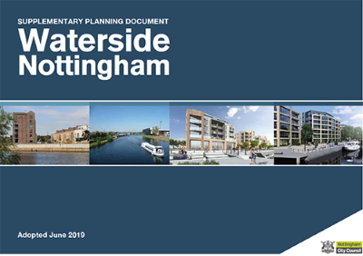
Vision - SPD Development
The Waterside Supplementary Planning Document or SPD that was
adopted last year provides the strategic urban design principles
that new development within the waterside regeneration zone
needs to respond to.
These include the creation of a new residential waterside
neighbourhood, a new primary school to provide vital social
infrastructure, and the establishment of a new public realm with
legible streets and spaces, as well as a new Riverside path and
associated green infrastructure.
Vision - SPD Connectivity
New development needs also to facilitate good connections for
both pedestrians and cyclists to the city centre and the
surrounding neighbourhoods. Most importantly, the SPD calls for
the establishment of more people friendly spaces.
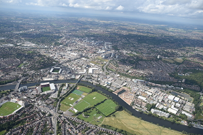
There is no doubt that Trent Basin is a pivotal site within the
wider waterside regeneration area. While it is located towards
the eastern end of the SPD subject zone, it is the only site
with a significant historic wharf that sits perpendicular to the
river and provides a water focus at the heart of the new
development area.
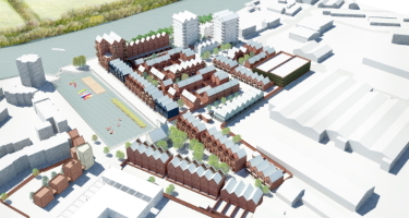
Trent Basin Context
The remaining Trent Basin development area now includes the site
for the new primary school and a mobility hub at the head of the
basin. It will also deliver new strategic pedestrian connections
both east west along the riverside and north south from the
riverfront to Daleside Road. The site's significance means it
will be the local centre for the wider riverside community as it
grows over the coming years.
Trent Basin Hybrid Planning Application Strategy
The proposals presented here will be submitted as a hybrid
planning application with part of the site designed in detail
and the remainder drawn in outline. The development area
supports 199 dwellings of which 122 houses and 23 apartments are
planned in the detailed area. The outline area supports a
further 54 dwellings with an indicative mix 46 apartments and 8
houses.
Existing Site Conditions
The photographs that accompany the site layout show the site
conditions today and you can see that large areas of the site
are unused with other sections occupied by large industrial
sheds some of which are still occupied.
The boundary conditions are important and very different in
character. We have the verdant nature of the river with all its
natural landscape on the south side of the site and then the
existing industrial areas to the east and west. While both these
areas are due to be transformed in the coming years, we still
need to be mindful of the transition period for the new
residents at Trent Basin. To the north the site has a new
boundary onto the busy Daleside Road.
The large water body that we know as Trent Basin dominates the
centre of the development area measuring 36.4 metres wide by 113
metres long. It is an amazing resource both to look over and to
bring water side leisure activities to the heart of the
neighbourhood. The water level is approximately three metres
below the existing tow path. We will see later in the
presentation how landscape architects BBUK have mitigated this
level difference.
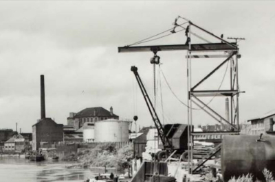
Trent Basin History
Trent Basin has a very interesting history. It was built in the
1930s as a timber wharf and in its heyday had some very
significant buildings and wharf side cranes set around its
edges. Obviously, the scale of the basin reflects its industrial
past and the historic images show the large ships that docked
here and the dockside equipment that supported the movement of
timber.
So, we have this fascinating historic context to work with and
as architects, we are interested in the way in which we can
combine this historic industrial scale alongside new housing fit
for our Century. The challenge is how we create a contemporary
residential quarter for Nottingham that can respond to this
spatial context and deliver an appropriate domestic
architecture.
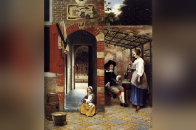
Spatial Context
There are a number of precedents, both from the immediate
context and from further afield that help us begin to think
about appropriate urban spatial structures, as well as an
architectural language. Nottingham's historic core, its original
medieval streets and hidden courts and alleyways are relevant as
are Dutch examples like Delft where domestic architecture forms
strong frontage to the canal side as well as providing clear
thresholds to quieter courtyard spaces behind.
The accompanying images illustrate this with both contemporary
pictures of Nottingham and Delft, in the Netherlands. The famous
17th Century paintings of Delft by Pieter de Hooch depict
domestic spaces that still exist to this day and demonstrate the
importance of urban thresholds in forming increasingly private
space. Delft's handsome domestic architecture, its canals and
people friendly spaces make it one of the most sought-after
cities to live in in Holland.
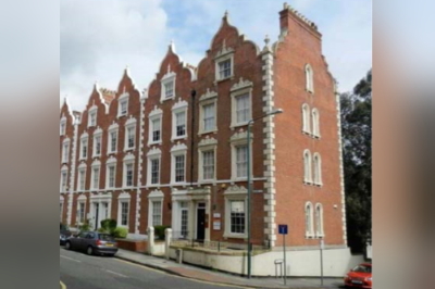
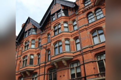
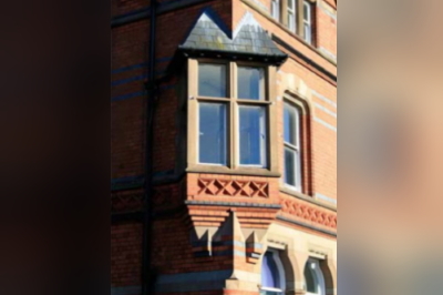
Architectural Context
The East Midlands and particularly Nottingham has its own
architectural character, and this can also inform a contextual
design approach at Trent Basin. Nottingham Leicester and Derby
all have a prevalence of red and blue brick as well as the use
of Colley Western stone employed to augment brickwork and
emphasize important details.
These materials are bought together in some of the best Arts and
Crafts buildings of the period in Nottingham. We show here a
number of buildings by Watson Fothergill and it is interesting
to note that Fothergill skilfully employs a domestic language on
buildings of multiple scales.
Principle Movement Corridors - Vehicular Network
In this section of the presentation we talk about the creation
of a 21st Century neighbourhood. The masterplan is designed to
support a hierarchy of public and private realm space. This
begins with the three site wide movement corridors; the
principal movement corridors that are referred to in the SPD.
We've got the new East West vehicle connection across the site,
which is called Kilpin Way, a section of the new Riverfront path
including a new pedestrian bridge across the head of the Basin
(and access for pedestrian around all sides of the Basin),
as well as a new pedestrian connection through a new pocket park
to Daleside Road.
Principle Movement Corridors - Shared Surfaces
The new Kilpin Way that connects Poulton Drive in the west with
Trent Lane in the east has been designed as a shared surface
residential street to keep traffic speeds as low as possible.
At present the road is configured to allow only free movement
for pedestrians and cyclists at the northern end of the basin,
with access for emergency and maintenance vehicles when
required. It is hoped this configuration will allow arguably the
most important public realm space within the waterside
regeneration zone to be a people place rather than a busy
through route for cars.
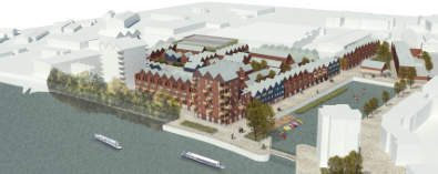
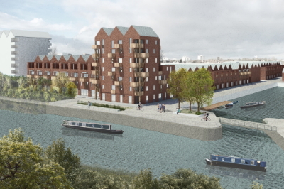
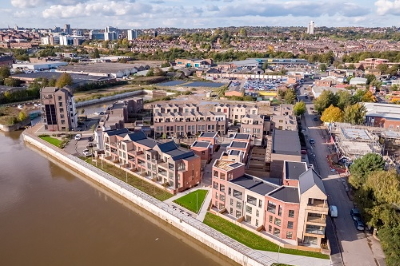
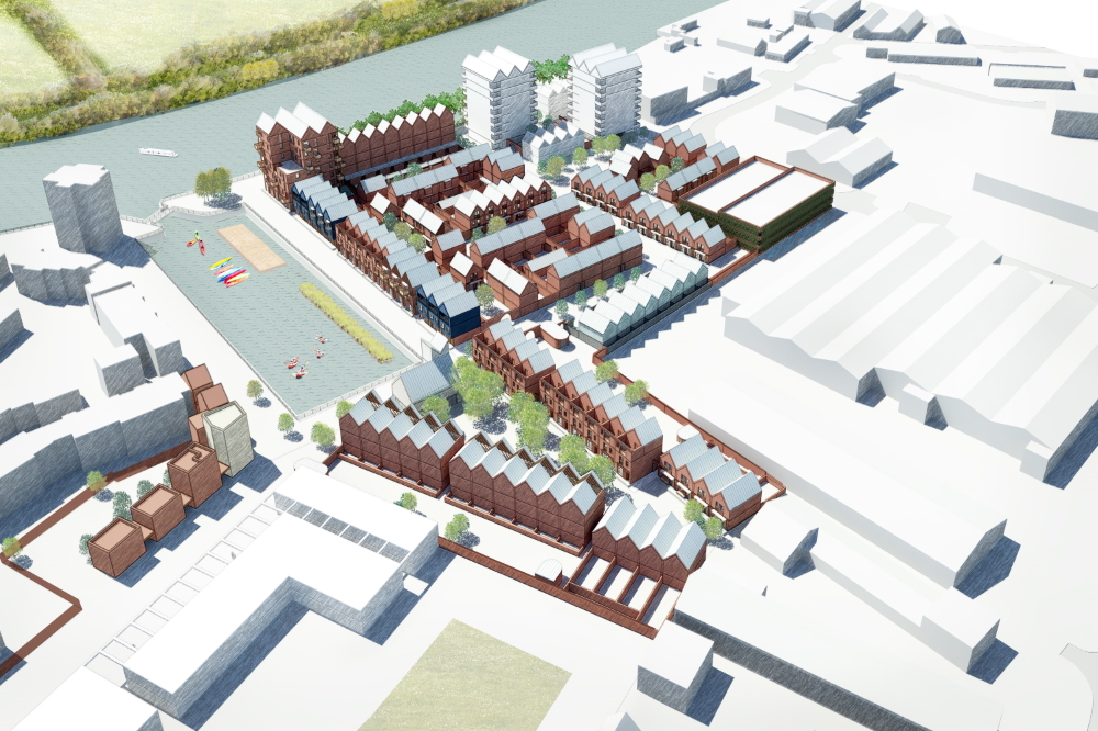
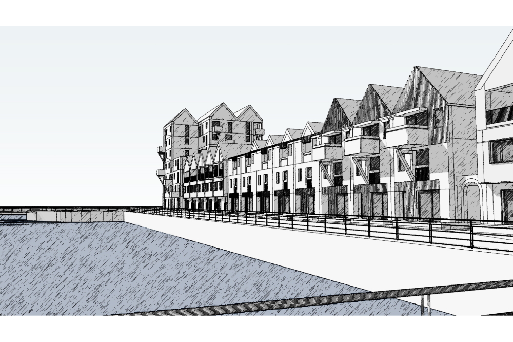
Spatial Hierarchy - Aerials
The built form proposed configures a hierarchy of spaces of
different scales, which in turn supports different house types
and shared surface environments. The accompanying aerial views,
illustrated here, show the development from all angles and
clearly indicate the roof profiles, urban structure, the grain
of the built form and the public spaces.
Building Heights
Our diagrams also show the building heights and the way they
support the master plan’s spatial structure with taller housing
topologies providing strong frontages to both the basin, the
riverfront and the triangular pocket park that leads through to
Daleside Road.
Townscape Markers
The urban form is punctuated with what we call 'marker
buildings'. These are buildings or individual houses that
provide townscape incidence at important junctions throughout
the plan. The larger apartment buildings which are arranged as
tall villas serve this function on the more expansive frontages,
while smaller houses will be detailed to play this same role
within the lower scaled sections of the plan.
The new mobility hub building, which will be a little public
building set at the northern end of the basin is also planned as
an important marker, which can be seen from all vantage points.
It is particularly important that it is seen from the new
entrance to the site on Daleside Road.
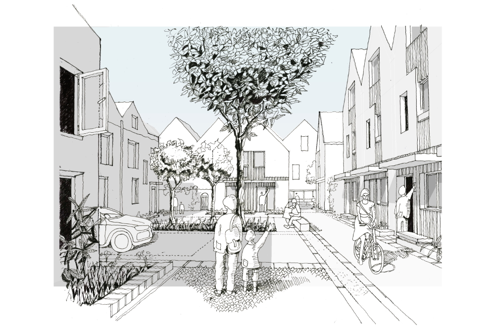
Behind the principal frontage is a sequence of smaller sheltered
residential courtyards. These are arranged and connected by
semiprivate pedestrian routes. The smaller marker structures
(houses with slightly different treatments) within these lower
scaled areas also augment important vistas and act as way
finders. They also deliver a townscape sequence at a more
intimate scale as people move around the development.
Townscape Markers continued
The sheltered courtyards spaces are the complete opposite of the
more expansive frontages across the Basin and of course across
the wide River Trent. These are sheltered spaces where small
children can play, and there can be neighbourly interaction.
These spaces generally support the lower scale dwellings. The
courtyards are all designed as shared surface spaces with the
provision for drop off and disabled parking.
Waterside Frontages
The sketch views that you see here of the River and Basin fronts
give a sense of the importance of these principal public
thoroughfares and the larger scale buildings that support these
routes. The sketch view of one of the residential courtyards
illustrates the contrast between these two kinds of environment.
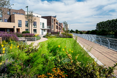
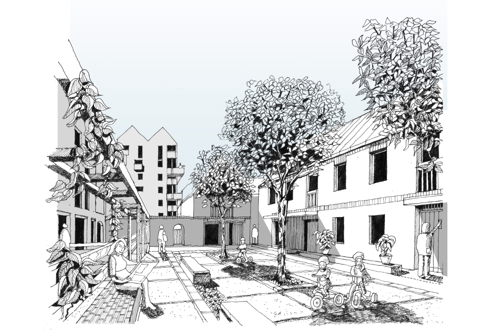
Public Realm Landscaping
It is important to note that the landscape treatments also act
in tandem with the organisation of the built form. New landscape
and public realm treatments are used to augment the Riverfront
path and to provide a public space at the southern end of the
basin. A pontoon is proposed within the basin with graduated
steps that allow people easy access to the water. The new pocket
park at the northern end of the basin is designed as a
neighbourhood wide amenity space.
The landscape treatments in the principle public realm contrasts
with that proposed within the sheltered housing courtyards. Here
shared surfaces, benches, rain gardens and specimen tress create
places for immediate neighbours to sit, talk and for children to
play.
People Friendly Public Realm
The extensive people friendly public realm that stitches the
development together is made possible by the introduction of a
'car barn'. Most of the required parking (although not all) is
located within the barn and this frees up space for people and
landscape rather than cars. This is not a new idea and was used
at the Greenwich Millennium Village 20 years ago where the
streets and spaces have become the focus of community life. It
was also pioneered at Vauban in Freiberg Germany which is one of
Europe's most sustainable developments.
The barn also allows us to future proof car parking requirements
without affecting the public realm and provide opportunities for
things like car clubs and for efficient electric car and bike
charging. This approach means that in the future if car
ownership diminishes and more people are prepared to use car
clubs or car rental, then the public realm is not sacrificed for
cars. It also allows us to design homes that are more
sustainable and move us closer to a zero-carbon future. Many
more developments throughout the UK are adopting the advantages
of this approach.
A Mix of Housing
The accompanying dwelling mix diagram shows the broad range of
typologies that the masterplan supports. There are one, two, and
three-bedroom apartments as well as two, three and four bedroom
family houses. This range of types will help support a mixed
neighbourhood of first-time buyers, families and downsizes. A
lot of thought has also gone into the way we plan these houses
so that they support modern family life with kitchen and living
spaces connected directly to gardens, and separate homework
stations incorporated as part of the plans. Well planned private
amenity spaces and designated home working stations seem even
more important in a post Covid world.
Architectural Variety
Blueprint is also keen to bring architectural variety to the
masterplan. With this mind three practices have been engaged.
These include our practice Proctor and Matthews Architects, as
well as Sarah Wigglesworth Architects and Turner Works. All are
involved in creating different housing typologies within the
massing and organisation set by the masterplan. The practices
are also all interested in context (discussed earlier) and how
this can be interpreted in different ways. The accompanying plan
shows where each of these practices have been assigned homes to
design.
Emergency Access Strategy
Of course, it is important that the masterplan works in detail
and particularly from the point of view of access arrangements.
We are aware that with masterplans like the one we're proposing
here, where there are a lot of shared surface space, that the
way we manage the movement of vehicles, particularly emergency
and refuse vehicles, is going to be really important in for the
success of the neighbourhood.
We have worked closely with our engineers BWB who have tracked
the scheme for emergency vehicles so that we conform to Part B
rules. This is indicated on the attached plan.
Refuse Strategy
In addition, we have taken advise from Nottingham's waste team
on both capacities for central waste arrangement and access
rules. We have now met the waste team and they have confirmed
that they are happy with what is being proposed. Again, the
attached plan indicates how this will work.
Courtyard Living
In this next stage of the presentation, we look in a little more
detail at one part of the masterplan. Illustrated opposite is
one of the courtyard clusters of dwellings that make up
courtyard 2. These drawings and accompanying notes in both plan
and isometric show the design principles applied and make clear
how the public and private realm structures work at a smaller
scale.
Private & Communal Amenity Space
As with the wider master plan, building frontages combined with
garden walls provide a clear definition between the residential
courtyards, the private gardens and communal bin stores, which
are set within the private areas.
Importantly, these primarily car free residential courtyards
allow us to integrate the built form the landscape which is seen
in the sketch perspectives of the courtyards. We can also see
that the mix of housing delivered across the wider plan is
reflected here in one courtyard cluster.
Ground Floor Plans
The detailed ground floor plan of these courtyards shows how the
different typologies come together in a seamless built form to
support the routes and spaces. The houses are also planned to
allow principle spaces to overlook and enjoy the courtyards. The
basin front housing has been specifically designed with two
front doors, one to the basin and the other to the smaller
courtyards behind. Boundary structures in these courtyards give
privacy to these dwellings without becoming solid barriers. The
sketch perspective shows how they become part of the landscape
of these spaces.
First Floor Plans
The housing close to the pedestrian routes that link the
courtyards and the basin tow path are also arranged with windows
that overlook these spaces. The first and second floor plans
(also shown) indicate that fenestration at these levels is
maximised to the public realm and minimised on rear elevations
to limit any overlooking of private garden spaces.
Several of the plans are shown at a larger scale and illustrate
the flexible open plan dual aspect family rooms, as well as home
working provision and ample storage.
Architectural Expression
Finally, we have provided some sample elevations prepared by
each of the architectural practices. This is very much a work in
progress, but you can see that material selection is from the
immediate context, either of Nottingham or Trent Basin’s
industrial past and details are also being explored that take
inspiration from these sources. We look forward to discussing
this work further with both planning and urban design officers
as we progress to the next stage of work.
Summary
The project team has engaged informally with the Council over
the past 18 months and so we appreciate that many of you will be
familiar with the proposal presented here. We have had very
valuable feedback over this period and the current design and
presentation has evolved in response to this.
In this first formal engagement, we hope to receive feedback on
the strategic issues of urban design, scale and density, access
and parking, and our public realm and landscape approach.
Blueprint belief these proposals embody all the aspirations set
out in the SPD and that they represent the very best in the
design of sustainable neighbourhoods and low carbon housing for
our age.
Thank you for listening.
This site is to be used as a marketing and investment tool only and not for architectural or design purposes. Buildings, sites and features are represented as approximations of their true dimensions and the map does not account for terrain.
The data within the model is derived from a variety of open data sources and we thank the organisations attributed below for its provision.
| Data Source | License |
|---|---|
| OS Open Data | Contains Ordnance Survey data © Crown copyright and database right . |
| emapsite - OS Partner | Contains Ordnance Survey data © Crown copyright and database rights Ordnance Survey 0100031673. |
| OpenStreetMap Contributors | Contains OpenStreetMap data and derived data licensed under the Open Database Licence. |
This site was built on Explore and is actively maintained by Deetu. To find out more, please get in touch.